The Ryszard Szurkowski Route was created in 2024 on the initiative of the Association 'Dolnośląska Kraina Rowerowa' (Lower Silesian Cycling Land) to highlight and commemorate the origin of this outstanding Polish cyclist from Świebodów, a village located in the Krośnice commune, Milicz county, Lower Silesia. The route is more than 100 km long and runs through four communes - his hometown Krośnice and Milicz, associated with his childhood and youth, and Zawonia and Trzebnica, which he cycled through on many occasions in his bicycle. The route leads along places associated with Ryszard Szurkowski, i.e. his home village, school, parish church, cemetery. The route also includes the Krosnice mural, R. Szurkowski street in Zawonia, Prababka hill in the Kocie Mountains with the steepest climb (14%), always a challenge for every cyclist, or the asphalt from Kuźniczysko through Sułów to Szkaradowo, which he often rode, alone or in the company of fellow cyclists from Trzebnica or Milicz.
The vast majority of the route leads along district and commune asphalt roads in general traffic (shared with cars), with low traffic volumes. Asphalt roads were a priority due to the fact that Ryszard Szurkowski was a road cyclist and practically only rode on such roads. Surfaces such as forest roads and gravel roads also appeared in places, but only when it was not possible to route the route otherwise.

Logo of the Ryszard Szurkowski Route, designed by Konrad Moszyński, copyright: "Dolnośląska Kraina Rowerowa" Association
The route starts and ends in Krośnice, near the Ryszard Szurkowski Museum (planned to open in 2025) in Sanatoryjna Street, and forms loops. There is a Mural of Ryszard Szurkowski on the wall of the building complex of the School Complex, sports hall and swimming pool, in close proximity to the Museum.
The convenient location of the beginning of the route makes it possible to arrive by car and leave the vehicle in one of two car parks - one on the side of Sanatoryjna Street, at the entrance to the Krośnicka Przystań Swimming Pool (Sanatoryjna Street), and the other on the side of Lipowa Street, from where the wall painting is perfectly visible. Access from provincial road DW439 (Żmigród)-Milicz-Krośnice-(Syców) can also be reached by the Lower Silesian Railway from Wrocław or Krotoszyn.
The Szurkowski trail can be followed in both directions. The route in the direction from Krośnice towards Świebodów, Zawonia, Kuźniczysko and Sułów is easier, because one enters the Prababka hill located in the Zawonia commune from Skotniki. On the other hand, if someone wants to tackle this climb, they should follow the trail in the opposite direction, that is from Krośnice, towards Milicz, Szkaradowo, Sułów, Kuźniczysko and Zawonia. Then one enters Prababka from the direction of the village of Radłów - it is quite a long and demanding ascent, with a 14% gradient.
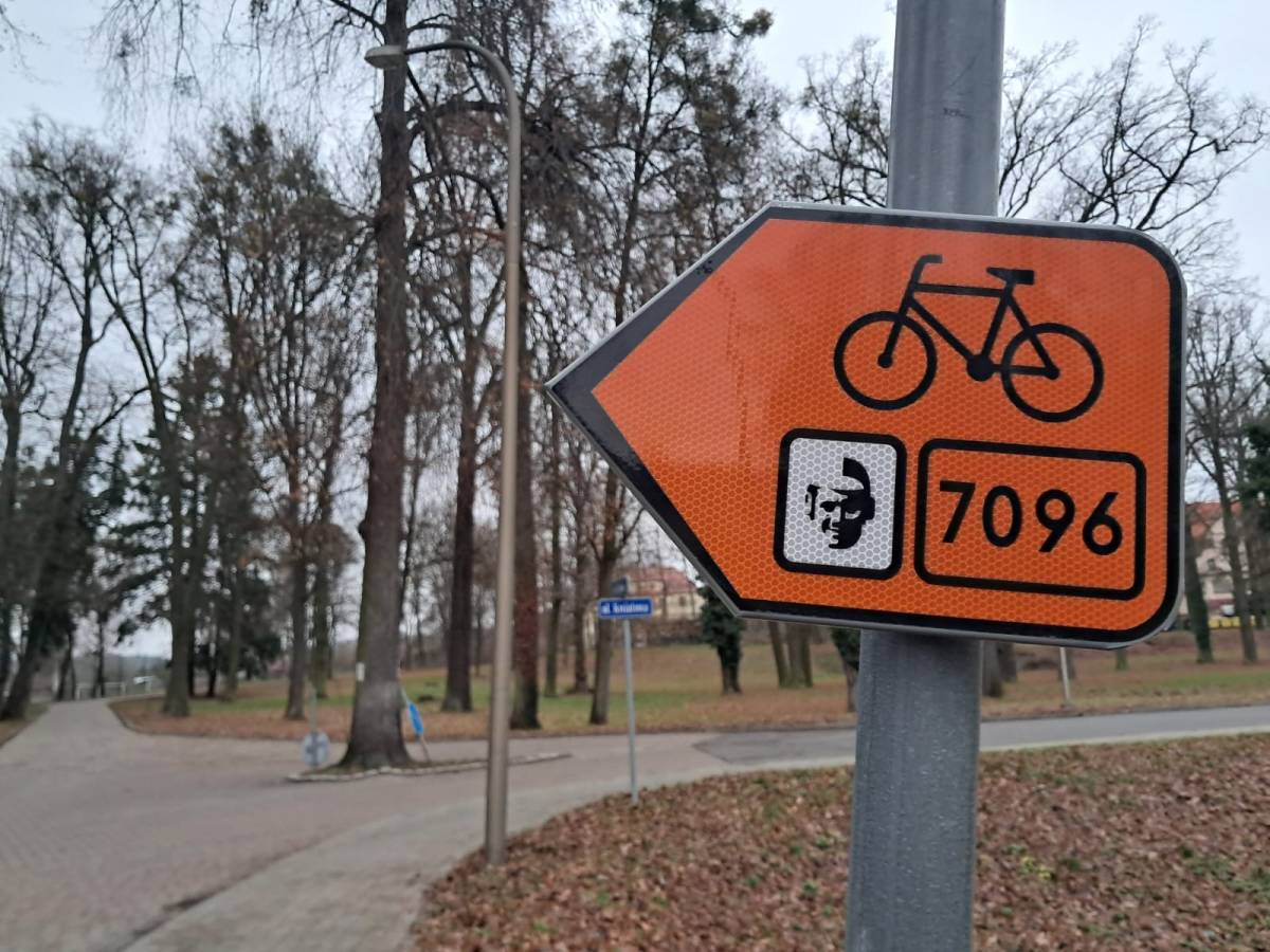
The trail is marked with R-4 signs in orange. The signs show the route number: 7096 and the route logo. The Ryszard Szurkowski Route, as the first in Lower Silesia, was marked according to the new concept of marking cycling routes, developed by the Marshal's Office of the Lower Silesian Voivodeship. Number #7096 is the first number from the pool provided for the Milicz county, where the route begins and ends and through which it runs the most kilometres.

Signage on the Ryszard Szurkowski Route (R4 and R4b signs)
SITES ON THE ROUTE RELATED TO RYSZARD SZURKOWSKI:
- Museum of Ryszard Szurkowski in Krośnice, Sanatoryjna Street (museum in preparation, planned opening in 2025).
- Świebodów - the hometown of Ryszard Szurkowski and in it:
- the building of the former primary school attended by Ryszard Szurkowski (brick building in the centre of the village, now housing the village hall, shop and flats)
- Ryszard Szurkowski square
- Blessed Virgin Mary Church in Wierzchowice - the parish church of Ryszard Szurkowski, here he had his First Holy Communion and his funeral took place.
- Parish cemetery in Wierzchowice - this is where Ryszard Szurkowski's tomb is located in the family grave.
- Street of Ryszard Szurkowski in Zawonia
- Prababka Hill - a repeated place of cycling struggles with his friends cyclists from the Trzebnica KS "Szerszenie"
- An asphalt route from Zawonia, through Budczyce, Kuźniczysko, to Ujeździec, Sułów, Szkaradów, Gogołowice and Milicz - the route of Szurkowski's almost daily laps, which he still covered when visiting his hometown.

The building of the former primary school in Świebodów, attended by Ryszard Szurkowski

Square in memory of Ryszard Szurkowski in Świebodów

Grave of Ryszard Szurkowski in the cemetery in Wierzchowice
OTHER INTERESTING PLACES ON THE RYSZARD SZURKOWSKI TRAIL:
-
Dziewiętlin - a pond in the park, in the vicinity of the former (no longer existing) palace of the Hochbergs, only the farm buildings have survived
-
Gęślica Hill - the highest hill of the Krośnickie Hills - best accessed by a cross. trekking or MTB bike, nearby a forest "mushroom" - a shelter for stopping and resting
-
Czeszów - Niezły Młyn Hotel and Restaurant
-
Skotniki - Prababka Hill, beautiful views of the surrounding Trzebnickie Hills
-
Czachowo - Kissling family palace from ca. 1895
-
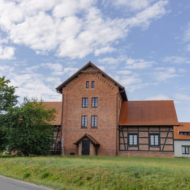
Kuźniczysko - larch Evangelical church from the 18th century and an old watermill from the beginning of the 20th century
-
Sułów - historic market square
-
Milicz - the Maltzans' palace, Grace Church, the Creative Multifunctional Facility with Druh Bolko's room and the Stara Bombkarnia Café
-
Wałkowa - Tree House - Forest and Nature Education Centre of the Milicz Forest District, with a public recreation area (rest stop)

Tree House - Forest and Nature Education Centre with a public recreation area amidst the greenery in Walkowa

Pond in the park in Dziewiętlin

The Prababka Hill, pleasant descent (14% gradient) from Skotniki towards Radłów
Map of the Ryszard Szurkowski Route (compiled by PLAN Publishing House):

With road cyclists in mind, an alternative route has been developed on tarmac and gravel, avoiding forest roads (which are periodically muddy or sandy).
Link to download the gpx track for the road variant (the route has a total distance of 114 km; to download the gpx, you must have an account on the Komoot app).
Elevation profile of the route in the direction: Krośnice - Zawonia - Skotniki (Prababka) - Sułów - Milicz - Krośnice (easier variant due to gentler uphill climb to Prababka Hill)

Elevation profile of the route in the direction: Krośnice - Milicz - Sułów - Radłów (Prababka) - Zawonia - Krośnice (a more difficult variant due to the steep climb up Prababka Hill from the Radłów side - 14% gradient):

The development and signposting in the field of the Ryszard Szurkowski Trail was made possible thanks to funding from the budget of the local government of the Lower Silesian Voivodship.


